


With a third of the world’s population locked down in the effort to fight COVID19, we’ve seen some amazing efforts at maintaining fitness and training regimes.
From the French runner Elisha Nochomovitz who ran an entire marathon on his balcony, to the UK Ultra-runner who did the same in his back yard, to the thousands of South Africans who have signed up to run a collective marathon in their back yards, 2kms per day, across their lockdown.
And while we heartily applaud the ingenuity and commitment, we’re throwing our hands up in exasperation at how utterly useless their run-trackers are at tracing the true route and metrics of their runs.
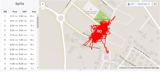
Take a look at the Balcony Marathon trace above, for example – if we were to believe Strava, then his balcony is a few hundred metres wide, spans several highways and includes elevation changes of over 20 vertical metres. Either that, or he is literally Ironman and can fly at will.
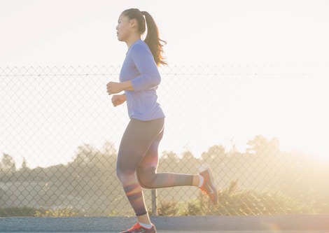
Another example: Ultra Runner Colin Harper ran a marathon in his backyard, running the precise amount of lengths of his 7m yard to tally to 42 km. And yet his Garmin trace on Strava estimates him to have run a full 10kms less – get back out there and keep going Colin!
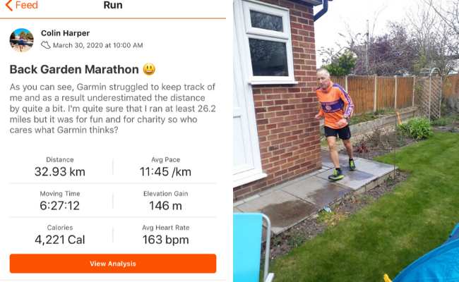
Colin Harper’s marathon, measured as 10km short by his Garmin Sports Watch
For Harper, who has run the legendary Marathon des Sables, this lack of truth from GPS wearables it’s not only frustrating, it’s also dangerous, especially when running in the wild: “There are occasions when it is really, really important to be the right side of a hedge or ditch but the level of accuracy of GPS isn’t high enough to indicate you are off-course by only a few metres. I have run several hundred metres on the wrong side of a hedge until the paths gradually diverged and I realised I was on the wrong one. I had no idea where I had missed the gap in the hedge, only that there was no way through where I was!”
Why are current fitness trackers so inaccurate? What’s really going on?
Running in confined spaces has shone a light on just how untrustworthy today’s wearables are in terms of reporting your location. Here’s why:
- Poor satellite reception/not enough satellites
By watching the films posted by Nochomovitz, we can see that his balcony has a limited view of the open sky. What that means is that when his sports wearable is trying to get “GPS Ready” aka get a satellite fix, it only has a small portion of the available satellites to look at. With just a few satellites to fix on, and all in the same region of the sky, his device would expect a margin of error around 60m – hence the trace thinking that he was flying, superman-style over the highway across from his balcony.
- Poor sensor fusion
Take a look at the elevations reported on the Strava trace, apparently his balcony ranges from +13m to -19m in elevation. This is probably because of both the poor GPS sky coverage and the barometer on his phone is getting confused by changes in temperature and pressure on the balcony, tricking it into thinking that he climbed the equivalent of 10 flights of stairs.
What he could have done
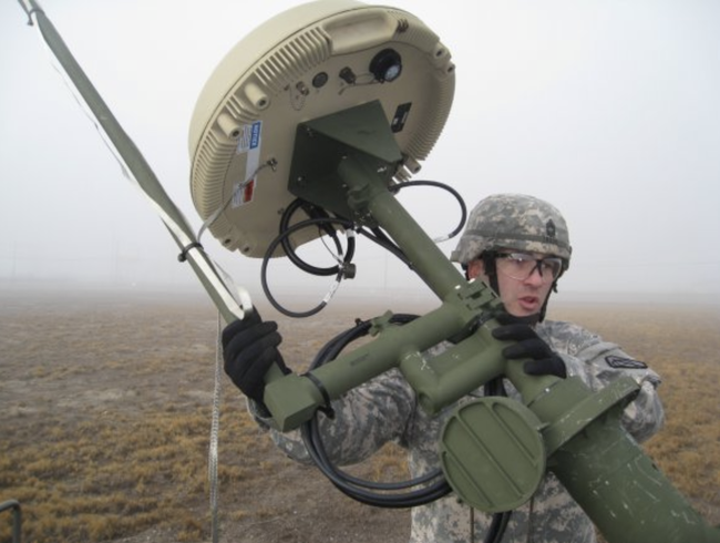
Unfortunately, unless he wanted to run with something like this military grade antenna on his back, he’s probably getting the ‘best’ data available from the wearables on the market; Colin runs with a high spec Garmin, for example.
That’s exactly why we’re working on bringing extremely high performance positioning tech to consumer wearables, to create positioning traces that are actually trustworthy.
Here’s what’s possible
We’ve been putting our D-Tail technology to the test in our backyard, running a heart-shaped trace to send out some positive energy in these testing times. Here’s what it looks like on a Garmin vs a Google Pixel equipped with our D-Tail technology. remember, this is run in a yard that is just 5m x 5m.
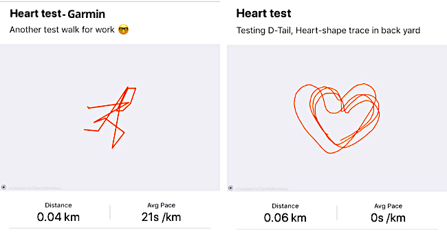
Two Strava traces for the same run in a 5m x 5m yard. Left: Garmin Sports Watch; Right: FocalPoint D-Tail
Our D-Tail technology creates a much higher integrity trace by using a machine-learning-driven human motion model to get a true picture of how runners move through space, together with precise sensor fusion to give us a reading of elevation.
Combine that with our S-GNSS technology, soon to be available in some consumer-grade smartphones, and you can expect a fix that is ten times better than today.
Why this really matters
Running marathons on balconies and back yards is all very well, but when you’re thinking about a near future world where we’re told we might be able to…
- Receive balcony-delivery by drones
- Accurately locate a lone-worker who has taken a tumble in the stairwell of the 6th floor of a high-rise building
- Get an accurate fix on vulnerable or high-risk persons
…then cm-level accuracy in positioning and elevation can mean the difference between life and death.
Want to find out more about our tech?
- Fellow runners – follow us on Strava and tweet us your back garden micro strava art 😉
- If you’re a professional runner and are interested in how we can give you a more accurate measure of your run, get in touch by filling in our demo request form
- Wearable analysts and experts please email us for more information
Share this post
Ramya Sriram leads marketing at FocalPoint, a UK-based company that provides GPS-enhancing software for automotive, wearables and smartphones.
Related post
GPS accuracy and running watches: Improving how we track our health and fitness
If you’re a runner, you might be used to the squiggly patterns that you trace on your GPS app: a chaotic maze of streets and paths. In fact, GPS route tracking has now even become an art form in itself: for example, this London jogger intentionally plans his routes to create animal illustrations while running and Strava artwork has grown in popularity.