


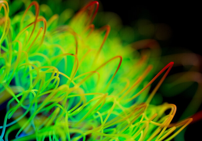
At first glance, this picture may evoke the iconic, chaotic style of American artist, Jackson Pollock, or a microscopic view of a plant. However, upon closer examination, you’ll notice this isn't the case.
What it is actually showcasing is the fluid movements of a mobile device – be it a smartwatch or a smartphone.
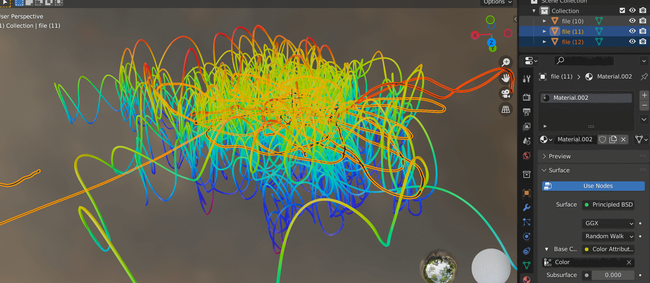
What’s depicted here is a detailed map of the device’s journey through space, tracing its location path relative to the user’s centre of gravity. This fascinating representation of data offers a unique perspective on the positioning of the device, highlighting its precise movements whilst mapping through the same spot in the middle, as represented here in the image.
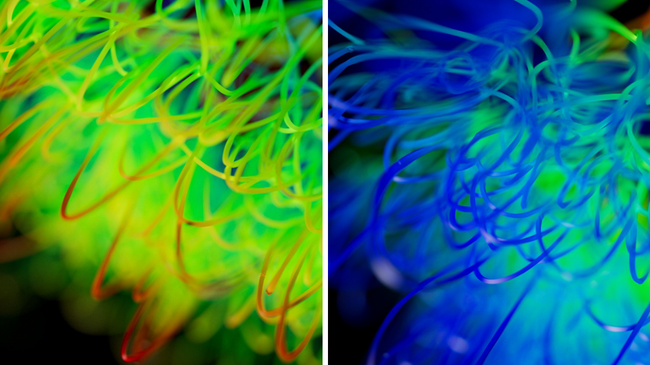
The fluid movement of a mobile device’s journey through space
Why is this of interest to our data teams?
Our data teams are always exploring new ways to understand and analyse GPS device data. In the data, they are looking for unique and consistent patterns of motion.
For example patterns in the data might constitute standing, walking, running to the varieties of different transportation modes. In addition, they are looking for patterns of movement that constitute walking at different paces, what might involve arm swinging and the various placements associated with carrying a mobile device. The gradients in our data is showing how much someone might be speeding up or slowing down.
They’re always on the lookout for short-term changes in direction or movement that don’t align with what we might consider as “normal” behaviour. Our teams are searching for deviations in the data from the mean position of the device. Essentially, they want to identify any differences between the position of the user and the position of the phone or watch, which might indicate that a pattern of behaviour is considered out of the norm.
In analysing our motion data in this way they are able to build a vital picture uncovering new insights into human behaviour and movement patterns.
The role of Machine learning in GPS
Machine Learning (ML) uses data to derive a model which is essentially programmed to think in a humanistic way. In the field of GNSS positioning, it plays an important role to improve positioning accuracy.
In combining machine learning with GPS data, we are essentially training a system to recognise patterns in one particular dataset (such as the inertial sensor measurements within a smartphone) using information from a different system as a guide (such as GPS measurements). In doing so, we can train a system how to estimate the information that would be provided by one sensor set, by looking at the measurements from the other. Similar to how your brain has learned that when you hear a barking sound, you will look around for a dog not a goldfish. You have learned over your life how the sight of dogs and the sounds of barking are tightly correlated in general. We train up classification algorithms to make similar connections between sensor sets and data types.
Real trial data
Whilst machine learning has been around since the 1960s it has evolved greatly over those 60 years.
Machine learning can be used to match patterns of GNSS measurements to particular environments or motion states in a manner that traditional procedural programming cannot utilise easily.
Combining machine learning with positioning technologies will provide a layer of autonomy to actions that can save lives – for example fall detection that can call the emergency services for you after you have had an accident that has incapacitated you.
Motion analysis and GPS
Combining GPS-derived training data with smartphone sensor data can allow higher accuracy position and velocity information to be determined in difficult environments when the GPS signals are unavailable. This has an impact on indoor positioning availability, and the provision of accurate location data during emergency situations indoors and in dense urban environments.
So whilst this image is a beautiful representation of the seamless integration between data and a human experience – it also presents an exciting glimpse into the future of mobile technology.
If you are interested in the work we are doing, why not take a look at our jobs board.
Share this post
Ramya Sriram leads marketing at FocalPoint, a UK-based company that provides GPS-enhancing software for automotive, wearables and smartphones.
Related post
GPS accuracy and running watches: Improving how we track our health and fitness
If you’re a runner, you might be used to the squiggly patterns that you trace on your GPS app: a chaotic maze of streets and paths. In fact, GPS route tracking has now even become an art form in itself: for example, this London jogger intentionally plans his routes to create animal illustrations while running and Strava artwork has grown in popularity.