






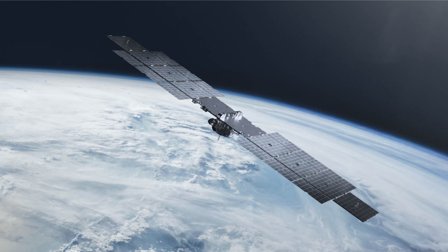
Image – Pulsar satellite over Earth; Credit: Xona
Xona’s Pulsar constellation promises stronger signals and a valuable new layer of positioning infrastructure. In this blog post, we examine what this means for navigation, and why advanced multipath mitigation will remain essential in challenging urban environments.
Summary
Xona’s recent regulatory milestone is important because it brings a new commercial layer of navigation infrastructure closer to reality. Its Pulsar constellation is designed to work alongside GPS, Galileo and other existing GNSS constellations, providing stronger signals and additional positioning and timing measurements. We warmly congratulate the Xona team on this remarkable achievement. This will clearly make navigation more available and resilient for vehicles, mobile devices and critical infrastructure. However, stronger signals cannot prevent buildings from blocking and reflecting radio waves, which remains one of the main causes of positioning error in cities. We believe the greatest benefit will come from combining LEO-PNT with existing GNSS and advanced receiver processing. Technologies such as Supercorrelation can help receivers identify reliable signal paths and suppress misleading reflections, allowing the expanded signal environment created by Xona to deliver its full potential.
A major milestone for commercial LEO-PNT
On Friday, 31 July 2026, the US Federal Communications Commission reached an important decision on Xona Space Systems’ application for its Pulsar constellation. The public licensing record describes the outcome as “Granted in Part / Deferred in Part” [1]. On Monday, 3 August, Xona announced the decision as a first-of-its-kind authorisation for full deployment of Pulsar, a milestone also reported by Via Satellite [2,3]. Xona’s Pulsar-0 demonstration satellite is expected to be joined by six production satellites in October 2026 as the company progresses towards a constellation of more than 250 LEO satellites [2,3]. This is excellent news for Xona and the wider navigation community. It brings the industry an important step closer to a new commercial PNT resource that can complement the satellite-navigation infrastructure on which modern economies already depend.
How Pulsar works
Pulsar is a purpose-built LEO navigation system whose X1 and X5 signals use offset centre frequencies within the wider L1/E1 and L5/E5 radionavigation bands, as illustrated in Figures 1 and 2 [4,5]. This design allows many existing GNSS antennas and radio-frequency front ends to receive the signals. Where the receiver hardware has suitable bandwidth and processing capability, Pulsar support may be added through firmware rather than requiring an entirely new receiver architecture [4,6].
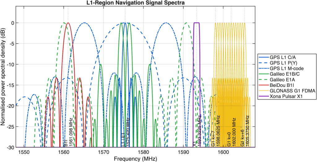
Figure 1: Illustrative placement of Xona Pulsar X1 in the L1/E1 frequency region. Carrier positions and approximate occupied regions are based on published specifications and public regulatory material. The displayed spectral shapes are simplified modulation models, independently normalised for visibility, and are not ICD-grade power spectral densities, emission masks or relative-power comparisons. The figure is intended only to orient the reader within the spectrum. X1 is positioned between the principal upper-frequency GPS L1/Galileo E1 components and the GLONASS G1 FDMA allocation. Sources: [4–6].
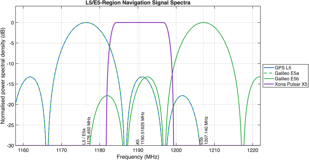
Figure 2: Illustrative placement of Xona Pulsar X5 in the L5/E5 frequency region. Carrier positions and approximate occupied regions are based on published specifications and public regulatory material. The displayed spectral shapes are simplified modulation models, independently normalised for visibility, and are not ICD-grade power spectral densities, emission masks or relative-power comparisons. The figure is intended only to orient the reader within the spectrum. X5 lies in the central region between the Galileo E5a and E5b lobes, close to, but not exactly at, the centre of the combined E5 AltBOC allocation. Sources: [4–6].
The planned Pulsar constellation will orbit at approximately 1,080 km, far closer to Earth than conventional GNSS satellites in MEO. The shorter propagation distance produces substantially lower free-space path loss, and Xona specifies received signal powers approximately 15 to 20 dB above comparable GPS signals, equivalent to as much as 100 times the received power [4,5]. This stronger link can improve reception in attenuated and interference-prone environments, although it cannot eliminate physical blockage or guarantee immunity from sufficiently powerful jamming. X1 and X5 use offset centre frequencies and compact modulation designed to coexist with incumbent GNSS signals. Xona’s published analysis, simulation, commercial-receiver testing and live-sky measurements report no adverse interference effects on the GPS and Galileo services evaluated [6].
Pulsar also introduces modern security features. These include cryptographic data authentication and a dynamic watermark embedded in the ranging code, allowing a compatible receiver to test whether a measured pseudorange is authentic [7]. Such capabilities are increasingly relevant as deliberate GNSS spoofing and jamming affect civil aviation and maritime operations, with Royal Institute of Navigation (RIN) reports documenting navigation errors, equipment disruption and associated safety risks [8,9]. Authentication does not prevent every possible attack, but it gives receivers an important additional mechanism for detecting manipulated navigation signals.
The challenge in urban environments
Stronger signals are a major advantage, but they do not change the fundamental physics of urban radio propagation. Buildings, vehicles and other structures can still block, reflect and diffract LEO-PNT signals, just as they do conventional GNSS signals. This produces multipath, where direct and reflected components arrive together, and non-line-of-sight (NLOS) reception, where the receiver tracks only a reflected signal [10–12]. Higher received power may allow additional attenuated reflections to become visible above the receiver’s noise floor, especially at low elevation angles more commonly observed for LEO satellites than MEO. That can preserve signal availability, but it also reinforces an important engineering principle: a strong signal is not necessarily an accurate one.
This is where FocalPoint’s Supercorrelation technology is particularly relevant. Supercorrelation combines extended coherent processing with knowledge of receiver motion to create signal-domain spatial discrimination. Energy arriving from the expected satellite direction can be reinforced, while reflected components arriving from other directions can be suppressed [13–15]. Pulsar also introduces characteristics that differ markedly from MEO GNSS, including larger Doppler shifts, faster Doppler rates and more rapidly changing lines of sight [5,16,17]. These dynamics may provide additional temporal and spatial diversity that Supercorrelation can exploit, although the magnitude of that benefit must still be validated using operational LEO-PNT signals.
The way forward
The greatest opportunity lies in combining new LEO-PNT signals with existing GNSS and the receiver technologies needed to use both reliably. The systems can be processed together, increasing the number and diversity of available measurements. Urban-navigation studies indicate that integrated GNSS and LEO observations can improve geometry, availability and positioning convergence [10,19]. Combining those measurements with advanced multipath mitigation offers the prospect of a more reliable overall solution: LEO-PNT supplies valuable new signals, while technologies such as Supercorrelation help receivers determine which signal paths can be trusted.
Xona’s progress is great news for the PNT industry. Pulsar promises stronger signals, rapidly changing geometry and an independent source of positioning and timing information that can complement established GNSS. These capabilities will expand what navigation receivers can achieve, but they will not eliminate challenges such as blockage, reflection and non-line-of-sight reception in dense urban environments.
Supercorrelation can help receivers identify trustworthy signal paths, suppress misleading reflections and maintain better positioning performance in difficult environments. With this major regulatory milestone reached and the next Pulsar satellites approaching launch, Xona is opening an exciting new chapter in commercial satellite navigation. We look forward to helping the wider ecosystem realise the full value of this new PNT resource.
To read more about how Supercorrelation works, download the white paper.
References
[1] Federal Communications Commission, “Xona Space Systems, Inc., Application SAT-AMD-20251119-00328,” International Communications Filing System, decision dated 31 July 2026. View the FCC filing record.
[2] Xona Space Systems, “Pulsar Receives First-of-Its-Kind FCC Authorization for Full Deployment,” 3 August 2026. View Xona’s announcement.
[3] R. Jewett, “Xona Gets Approval to Deploy Commercial Navigation Constellation,” Via Satellite, 3 August 2026. View the report
[4] T. Marathe, T. G. R. Reid, S. Tantry and M. O’Meara, “Xona Pulsar Single-Satellite Positioning: System Perspective and Experimental Validation,” in Proceedings of the 2026 International Technical Meeting of the Institute of Navigation, Anaheim, CA, USA, Jan. 2026. Available online.
[5] J. Leclère, T. Marathe and T. G. R. Reid, “Insights into Xona Pulsar LEO PNT: Constellation, Signals, and Receiver Design,” in Proceedings of the 38th International Technical Meeting of the Satellite Division of the Institute of Navigation, Baltimore, MD, USA, pp. 3008–3096, Sept. 2025. Available online.
[6] T. G. R. Reid, M. Gala, M. Favreau, A. Kriezis, M. O’Meara, A. Pant, P. Tarantino and C. Youn, “Xona Pulsar Compatibility with GNSS,” in Proceedings of the 38th International Technical Meeting of the Satellite Division of the Institute of Navigation, Baltimore, MD, USA, pp. 929–943, Sept. 2025. Available online.
[7] J. Anderson, “World’s First Authenticated Satellite Pseudorange from Orbit,” presented at the 38th International Technical Meeting of the Satellite Division of the Institute of Navigation, Baltimore, MD, USA, Sept. 2025. Available online.
[8] Royal Institute of Navigation, “GPS Spoofing in the Civil Aviation Sector,” RIN and OpsGroup industry report. Available online.
[9] Royal Institute of Navigation, “The Impact of GNSS Interference on Maritime Safety,” Navigation News, Mar.–Apr. 2026. Available online.
[10] M. Alghisi, L. Biagi, S. Bianchi, A. Gatti and M. Nicoli, “Augmenting GNSS with LEO-PNT and 5G for Enhanced Positioning in Urban Environments,” NAVIGATION: Journal of the Institute of Navigation, vol. 73, no. 1, Art. no. navi.770, 2026. Available online.
[11] Q. Zhang et al., “Analysis of Multipath Effects on LEO Ranging-Based Positioning in Urban Environments,” Advances in Space Research, 2025. Available online.
[12] P. D. Groves, Z. Jiang, B. Rudi and P. Strode, “A Portfolio Approach to NLOS and Multipath Mitigation in Dense Urban Areas,” in Proceedings of the 26th International Technical Meeting of the Satellite Division of the Institute of Navigation, Nashville, TN, USA, Sept. 2013, pp. 3231–3247. See also the distinction between multipath and NLOS reception in this technical overview.
[13] R. Faragher, N. Couronneau, M. Powe, P. Esteves, M. Crockett, H. Martin, E. Ziglioli, C. Higgins and D. Buckle, “Supercorrelation: Enhancing the Accuracy and Sensitivity of Consumer GNSS Receivers with a DSP Upgrade,” in Proceedings of the 31st International Technical Meeting of the Satellite Division of the Institute of Navigation, Miami, FL, USA, Sept. 2018, pp. 357–375. Available online.
[14] J. G. Garcia et al., “Enhancing GNSS Robustness in Automotive Applications with Supercorrelation: Experimental Results in Urban Scenarios,” Engineering Proceedings, vol. 88, no. 1, Art. no. 75, 2025. Available online.
[15] FocalPoint Positioning, “Supercorrelation Technical Overview,” technical white paper. Available online.
[16] F. Prol et al., “Analysis of Multipath Code-Range Errors in Future LEO-PNT Systems,” presented at the European Navigation Conference, 2023. The study reports multipath phase-delay rates as much as 75 times those of comparable MEO cases and simulated code-range errors up to 96% lower for rapidly changing multipath—publication record.
[17] A. Allahvirdi-Zadeh, K. Wang and A. El-Mowafy, “Doppler Positioning Using Multi-Constellation LEO Satellite Signals of Opportunity,” NAVIGATION: Journal of the Institute of Navigation, vol. 72, no. 2, Art. no. navi.691, 2025. Available online.
[18] H. More, A. N. D’Andrea, G. Seco-Granados and E. S. Lohan, “Comparing Positioning Performance of LEO Mega-Constellations and GNSS in Urban Canyons,” IEEE Access, vol. 12, 2024. Available online.
[19] M. Alghisi and L. Biagi, “Integration of GNSS and LEO-PNT for Precise Positioning: A Simulation in Urban Environment,” in Proceedings of WIPHAL 2025, Rome, Italy, June 2025. The simulated hybrid system reduced PPP convergence time by as much as 80% under the study’s elevation-mask model. Available online.
Share this post

J.R. (Ross) van der Merwe is a Chartered Engineer (CEng) specialising in resilient navigation systems. He holds an M.Eng. (University of Pretoria, South Africa), a doctorate in GNSS spoofing (Friedrich-Alexander University Erlangen-Nuremberg, Germany), and an EMBA (Quantic, USA). He currently develops and validates technologies to protect GNSS systems against spoofing, multipath, and interference.
Related post
Webinar: How FocalPoint and ST are delivering reliable GNSS for autonomous driving
FocalPoint and STMicroelectronics present the latest results from testing S-GNSS® Auto on Teseo devices in challenging environments around the world.