







High-precision positioning using global navigation satellite systems (GNSS) is becoming increasingly important across various applications, from autonomous vehicles and robotics to surveying and asset tracking. Yet conventional high-precision GNSS degrades in challenging environments where signals are blocked or obscured, become dominated by reflections or are corrupted by multipath interference. We recently put our next-generation Precise+® technology to the test under dense tree cover in Thetford Forest, Norfolk, demonstrating its ability to deliver high-precision positioning where conventional approaches fall short. Here, Javier Garcia, Principal GNSS Engineer and Precise+ team lead, outlines what the results reveal.
Standard-precision GNSS – the technology behind everyday positioning in phones, watches and cars – is accurate to around 2 metres in open sky. However, its accuracy degrades to 10 metres or more when satellite signals are obscured or blocked in cities and under tree cover. High-precision GNSS – used in applications such as autonomous systems and robotics – uses carrier phase measurements to deliver centimetre-level positioning in open sky; however, it is also acutely vulnerable to reflections, multipath and signal blockage. In heavy foliage and deep urban canyons, it suffers from loss of lock and carrier wave cycle slips, sharply reducing both accuracy and availability. As a result, receivers in challenging environments are often unable to maintain a high-precision solution, instead outputting a level of performance no better than that of standard GNSS.
FocalPoint’s next-gen technology Precise+ extends the open-sky performance of high-precision GNSS into cities and other signal-degraded environments. Precise+ helps receivers maintain reliable carrier-phase tracking when signals are degraded by foliage and tall buildings. This makes it particularly relevant for applications that depend on high-precision positioning, such as ADAS, autonomous vehicles and robotics.
Supercorrelation®, FocalPoint’s patented technology, inherently suppresses multipath and has already delivered major improvements in code-phase and Doppler quality in challenging environments. Precise+ extends the benefits of Supercorrelation to carrier phase for the first time, generating multipath-free Accumulated Delta Range (ADR) observables that help bridge deep signal fading and prevent cycle slips, leading to enhanced positioning performance.
Designing the trial
To accurately assess performance under challenging conditions, the team at Focal Point Positioning carried out a live trial in Thetford Forest in Norfolk using their software-defined radio (SDR) GNSS receiver (FPP-SDR).
The forest’s dense coniferous canopy severely attenuates and scatters GNSS signals, making it a demanding environment for both standard- and high-precision positioning systems.
The test vehicle was equipped with a roof box housing multiple GNSS antennas and a LabSat 4 record-and-replay system, enabling simultaneous data capture for post-processing with the FPP-SDR, and real-time comparison against third-party commercial receivers connected to high-precision live correction services. The ground truth reference trajectory was provided by a NovAtel SPAN ProPak7 dual-antenna GNSS receiver coupled with a NovAtel IMU-ISA-100C inertial measurement unit. This delivered centimetre-level positioning accuracy throughout the route and enabled receiver performance to be measured against a highly accurate baseline.
What the data revealed
Measurement Domain
Measurement quality was assessed by comparing observables generated by the FPP-SDR operating in three different configurations – Standard 20 ms, Precise+ 100 ms, Precise+ 1000 ms – against ground-truth-derived reference values. The values 20 ms, 100 ms and 1000 ms indicate the number of milliseconds of coherent signal integration performed in each configuration. ADR errors were evaluated using the Time-Differenced Carrier Phase (TDCP) method, which allowed epoch-to-epoch consistency to be measured independently of cycle slips and provided a clean view of carrier-phase quality.
The results demonstrated substantial improvements across all measurement categories. The table below shows the 95th percentile errors across the three receiver configurations for each type of measurement: pseudorange (code phase), pseudorange-rate (Doppler) and ADR. In all cases, Precise+ showed a significant reduction in errors compared to Standard processing, with longer coherent integration further boosting Precise+ performance.
Also shown in parentheses are ADR error statistics generated from the most dense foliage sections of the trial. As expected, the benefits of Precise+ are even more pronounced with a 66 percent reduction in the 95th-percentile ADR error relative to standard processing. These gains are particularly important because ADR quality directly affects the stability and reliability of carrier-phase positioning solutions.
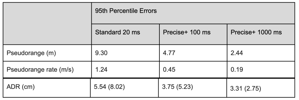
*Figures in parentheses show error statistics from dense-foliage sections only
Positioning Domain
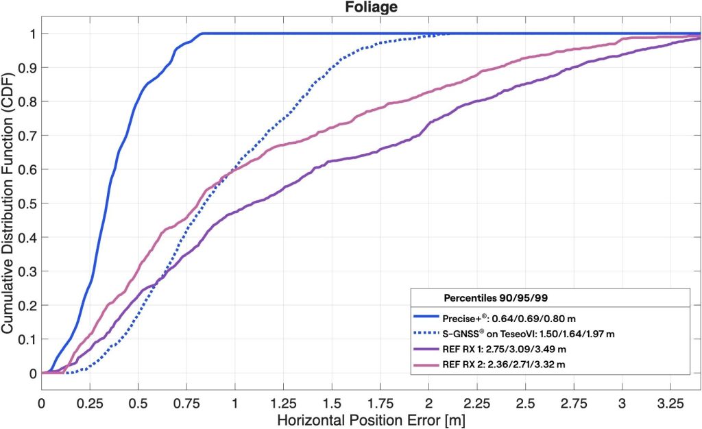
The impact of enhanced measurement accuracy on positioning performance was also demonstrated. In the figure below, high-precision positioning results from the FPP-SDR in Precise+ mode are compared with outputs from commercial receivers. Two state-of-the-art high-precision GNSS receivers with live correction data were used in the trial: REF RX 1 and REF RX 2, the latter being the only receiver trialled which featured inertial sensor aiding. Also included for comparison are standard-precision positioning outputs from a first-generation Supercorrelation-enabled receiver – an STMicroelectronics TeseoVI featuring FocalPoint’s S-GNSS® Auto software.
Under dense foliage, Precise+ maintained 0.69 m accuracy at the 95th percentile and remained sub-metre at the 99th percentile, achieving 0.80 m. By comparison, REF RX 1 and REF RX 2 recorded significantly larger 95th percentile errors of 3.09 m and 2.71 m respectively. Overall, Precise+ reduced 95th percentile positioning error by between 74 percent and 78 percent compared to these commercial high-precision receivers.
Precise+ fundamentally changes what is achievable under heavy foliage: consistent sub-metre positioning where state-of-the-art receivers with live corrections suffer multi-metre errors.
Also of note is the performance of the FocalPoint + STMicroelectronics TeseoVI S-GNSS receiver. Despite not featuring a high-precision navigation engine it still outperforms the commercial high-precision receivers under foliage, thanks to Supercorrelation’s multipath mitigation and sensitivity gains. Precise+ applies these same Supercorrelation benefits to carrier phase positioning, bringing reliable high-precision performance into the most challenging environments for the first time.
Implications for future positioning systems
While sensor fusion, inertial navigation and correction services will continue to play an important role in future positioning architectures, the trial demonstrates the importance of improving measurement quality at source. By enhancing receiver-level performance before additional technologies are introduced, developers can build a stronger foundation for autonomous vehicles, robotics and other GNSS-dependent systems.
The Thetford Forest results suggest that receiver-level innovations can extend reliable high-precision positioning into environments where conventional high-precision receivers fail. As autonomous systems move from controlled settings into everyday operation, being able to maintain reliable performance under challenging conditions will only become more important.
These results were first presented at the European Navigation Conference 2026 in Vienna, Austria.
See the poster
FocalPoint is working with leading chipset manufacturers to bring Precise+ to market. Contact us to learn more.
Cover photograph © Laurence Bennett
Share this post

Javier Garcia is a Principal GNSS Engineer and Precise+ Project Lead at FocalPoint. With over 20 years of experience as a GNSS engineer, he has led key initiatives including the development of the world's first real-time Supercorrelation (S-GNSS®) software defined receiver under the European Space Agency’s NAVISP programme. Previously, Javier established himself as a researcher and Assistant Professor at the National University of La Plata (UNLP) in Argentina.
Related post
Skyscan: Enabling spatial authentication of GNSS signals using a single antenna
How Skyscan uses Supercorrelation® and a single antenna to verify where GNSS signals come from, with real-world results from a meaconing scenario at Jammertest 2025.